


eSURV
An innovative system for three-dimensional recording of the geometry of the surrounding environment, as well as the position and configuration of traces and objects at the scene of a traffic accident, crime, or fire, and any other incident requiring the documentation of spatial r...
Turnkey supply, installation and training · Service across Ukraine

 An innovative system for three-dimensional recording of the geometry of the surrounding environment, as well as the position and configuration of traces and objects at the scene of a traffic accident, crime, or fire, and any other incident requiring the documentation of spatial relationships. The eSURV system is designed, in particular, for police departments and other experts.
How It Works
The system provides full digitization of the documentation process at the scene of an incident. This allows for accurate digital 3D measurements, the preparation of sketches and site plans, as well as 3D visualization and reconstruction of incident scenes. It is based on geodetic measurement methods, the idea of which is to accurately and reliably measure the surroundings while ensuring full control over the measurement at every stage of documentation carried out in the field. The most important element of the system is specialized software developed specifically for the needs of inspecting and documenting incident sites. The eSURV measurement control program is responsible for data collection, processing, and process automation, and is fully compatible with on-site procedures and methodologies.
An innovative system for three-dimensional recording of the geometry of the surrounding environment, as well as the position and configuration of traces and objects at the scene of a traffic accident, crime, or fire, and any other incident requiring the documentation of spatial relationships. The eSURV system is designed, in particular, for police departments and other experts.
How It Works
The system provides full digitization of the documentation process at the scene of an incident. This allows for accurate digital 3D measurements, the preparation of sketches and site plans, as well as 3D visualization and reconstruction of incident scenes. It is based on geodetic measurement methods, the idea of which is to accurately and reliably measure the surroundings while ensuring full control over the measurement at every stage of documentation carried out in the field. The most important element of the system is specialized software developed specifically for the needs of inspecting and documenting incident sites. The eSURV measurement control program is responsible for data collection, processing, and process automation, and is fully compatible with on-site procedures and methodologies.
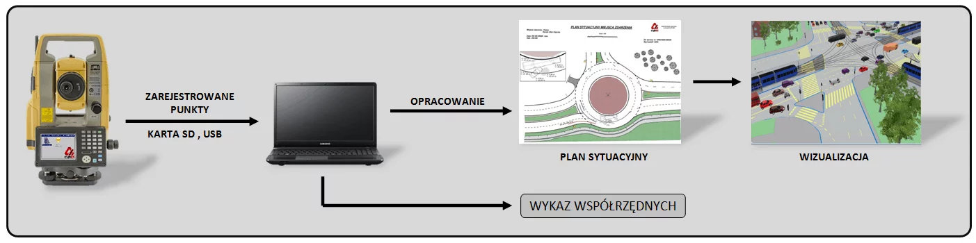 The system is highly effective for recording data at the scene of an incident, but can also be successfully used for other purposes. It can be utilized in:
- documenting traffic accidents and incidents (including documentation of technical experiments)
- documenting criminal and terrorist incidents (especially at crime scenes), as well as incidents inside buildings
- documenting fire scenes (what burned, burned-out objects)
- documenting aviation, rail, and construction disasters, as well as sites after floods or storms (assessing losses)
- converting digital photographs into an orthogonal projection based on photogrammetric measurements
- scaling three-dimensional objects obtained during the processing of digital photographs by recording characteristic lengths on the object
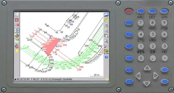
- Automatic sketch creation
- Built-in dictionary of basic track/object names
- Grouping of measured points into objects
- Ability to specify an SPO at any location
- Retrieval of data for the report
- Ability to create sketches in vertical projection
- Measure the height of an object directly from your device.
- Multiple data export formats
- Determination of any point in Cartesian coordinate space (X, Y, Z)
- Suitable for use in all weather conditions (temperature range from -20 to +50°C).
- A touchscreen LCD display, backlit screen, and laser pointer facilitate operation under any conditions (at night, while wearing gloves, etc.)
- Three independent aiming systems: a laser designator, a matte collimator for coarse aiming, and an optical sight with a reticle and 30x magnification for precise aiming.
- A special waterproof case protects the device from impacts and mechanical damage during transport.
- The measuring device and its accessories (tripod, pole with mirror, etc.) fit in the trunk of a standard car and can be transported by a single person.
Technical specifications
- Manufacturer
- Cybid
- Directions
- Forensics and special equipment
- Industries
- Forensics
- Type
- Equipment
Customer reviews
There are no reviews for this product yet. Have a question about operation or configuration? A specialist will reply within 24 hours.
Purchase, delivery and warranty terms
How to order?
Click “Price request” and leave your contacts. A manager will clarify the configuration, prepare a commercial offer and answer technical questions within 24 hours.
Delivery and supply
Direct supply from the manufacturer, no intermediaries. Lead time depends on the configuration and is fixed in the offer; we deliver across Ukraine.
Warranty and service
Manufacturer's warranty on the equipment. Installation, qualification and staff training; a service engineer responds within 48 hours.
Procurement documents
Commercial offer with and without VAT, contract specification. CE, ISO, IVD certificates, declarations of conformity and user manuals.
Frequently asked questions: eSURV
No questions yet — ask yours via a request.